TO EXPLORE • LOCAL GUIDE
Walking the Suffolk Coast: The Complete Guide from Aldeburgh to Southwold
There is an eerie, untamed romance to the Suffolk Heritage Coast. It is a landscape defined not by towering granite cliffs or pounding surf, but by shifting shingle banks, saltmarshes painted in shades of gold and rust, crumbling soft cliffs surrendering to the North Sea, and big, luminous skies that have captivated English painters for centuries.
Walking from Aldeburgh to Southwold is arguably the crown jewel of East Anglia’s long-distance footpaths. Spanning roughly 15 to 17 miles (24 to 27 km) depending on detours and whether the River Blyth row-ferry is operating, this day hike takes you through eccentric holiday villages, past nuclear monoliths, across wildlife-packed reedbeds and ancient heathland, through a “drowned” medieval city, and ends with a celebratory pint of bitter beneath a gleaming white lighthouse.
Whether you are an experienced rambler or an enthusiastic day-tripper looking for a classic British seaside adventure, here is your definitive, mile-by-mile field guide to walking from Aldeburgh to Southwold.
At a Glance: Route Vital Statistics
Trail Overview & Route Summary
Map & Route Profile Overview
Aldeburgh
Thorpeness
Sizewell
Dunwich Heath & Village
Walberswick
Southwold
The walk naturally segments into five distinct chapters, each with its own character and ecosystem:
- Chapter One: Aldeburgh to Thorpeness (The Literary Shingle & The Whimsical Folly)
- Chapter Two: Thorpeness to Sizewell Gap (The Brutalist Juxtaposition)
- Chapter Three: Sizewell through Minsmere to Dunwich (Wild Reedbeds, Heath & The Atlantis of Britain)
- Chapter Four: Dunwich to Walberswick (Pine Forests, Marshes & Crabbing Creeks)
- Chapter Five: Crossing the Blyth to Southwold (Harbourside Smokehouses to Victorian Elegance)
Essential Preparation & Practical Tips
1. Beware the Shingle Tax
Walking on shingle is the coastal equivalent of trekking through soft dry snow. Every two steps forward feel like one step back. While the purist’s instinct might be to walk right beside the breaking waves, doing so for 15 miles will shred your Achilles tendons.
Pro-Tip: Wherever possible, stick to the well-trodden compacted sand trails on the crest of the sea wall, the inland bridleways, or the designated Suffolk Coast Path markers tucked just 20 yards behind the primary shingle ridge.
2. The Walberswick Ferry Dilemma
At the end of your journey sits the River Blyth, separating Walberswick from Southwold.
- The Historic Row Ferry: A small wooden boat carries walkers across the narrow river mouth in about two minutes for a couple of pounds. It generally runs daily throughout the summer and on weekends during spring and autumn (weather permitting).
- The Backup Plan: If the ferry is closed, you will need to hike inland along the river path to cross the old railway footbridge (the Bailey bridge), adding approximately 1.5 to 2 miles to your total distance. Always carry cash for the ferryman, and verify operating hours beforehand!
Suffolk Hideaways
Discover handpicked coastal cottages, romantic hideaways, and family retreats across Aldeburgh and the Suffolk coast.
Explore Cottages →3. Footwear & Gear
- Sturdy Boots over Trail Runners: While the elevation is gentle, the combination of sharp flint pebbles, gorse needles, and sandy soil means trail shoes often fill with irritating grit. A light-to-mid hiking boot with good ankle support and a closed gusset tongue works best.
- Wind Protection: Even on sunny summer days, a blustery north-easterly wind blowing off the Arctic waters of the North Sea can bite. Carry a dependable windproof outer shell.
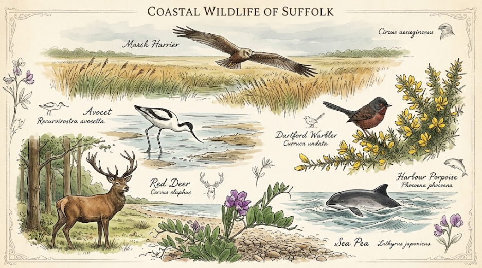
- Binoculars: Essential. You will skirt the borders of RSPB Minsmere—one of Britain’s premier nature reserves—where marsh harriers, bitterns, and avocets thrive.
Detailed Mile-by-Mile Walking Guide
Phase 1: Aldeburgh to Thorpeness (Miles 0 – 2.5)
Your journey begins on the seafront of Aldeburgh, a pastel-hued town famed for Benjamin Britten, literary festivals, and world-class fish and chips.
Starting Point: The Moot Hall
Head to the Aldeburgh Moot Hall, an intricate 16th-century timber-framed civic building that once stood in the center of the town, but thanks to half a millennium of coastal erosion, now sits perilously close to the beach crest.
Facing the sea, turn left and set your compass north.
Maggi Hambling’s “Scallop”
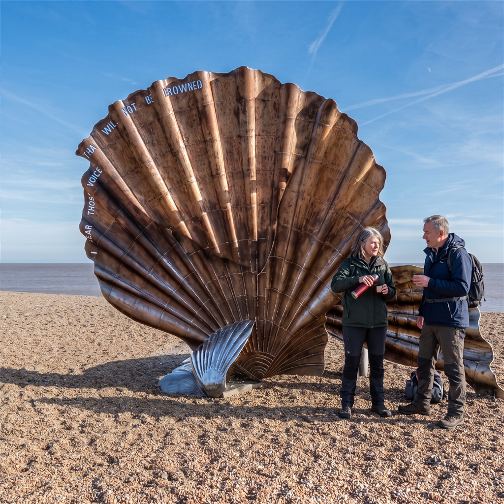
As you leave the town’s promenade behind, you step onto the vast expanse of shingle. Roughly a mile north stands one of the most talked-about public art installations in Britain: Maggi Hambling’s 12-foot stainless steel Scallop.
Erected in tribute to Benjamin Britten, the shell is pierced by the words: “I hear those voices that will not be drowned” (from his opera Peter Grimes). Climbing inside the hollow shell to watch the waves through its metallic curves is practically an East Anglian rite of passage.
Approaching the Fantasy Village of Thorpeness
Leaving the Scallop, continue north along the broad track running behind the shingle ridge. Soon, strange silhouettes pierce the horizon:
- The “House in the Clouds”: A whimsical 1920s cottage mounted atop a soaring water tower, designed to disguise the utilitarian infrastructure of a planned holiday village.
- The Thorpeness Windmill: A historic post mill relocated here by fantasy village mastermind Stuart Ogilvie.
Thorpeness was conceived before the First World War as an idyllic, mock-Tudor utopian playground for the wealthy. Take five minutes to wander inland past The Meare—a shallow boating lake inspired by J.M. Barrie’s Peter Pan, complete with pirate islands and tiny landing docks.
Pitstop Recommendation: Grab a morning coffee or pastry at The Kitchen in Thorpeness, or pause at the Dolphin Inn if you got an early start and fancy a quick rest.
Phase 2: Thorpeness to Sizewell Gap (Miles 2.5 – 5.5)
North of Thorpeness, the manicured lawns fade away into wild sea pea, yellow horned-poppy, and coastal scrub.
The Cliffs of Thorpeness
The path gently rises onto low sand-and-gravel cliffs. Look down at the beach to spot vintage fishing boats pulled up above high-water mark, their wooden hulls weathered silver by salt and sun. The path here is easy underfoot, weaving through gorse and broom that smells intensely of toasted coconut on warm days.
The Monolith of Sizewell
In the distance, an enormous white dome rises like a science fiction outpost dropped onto the wild coastline: Sizewell Nuclear Power Station.
- Sizewell A: Decommissioned and hulking.
- Sizewell B: The UK’s only commercial Pressurised Water Reactor, instantly identifiable by its gleaming spherical dome.
While hikers often grumble about industrial intrusion, walking past Sizewell provides a fascinating clash of brutalist human engineering and natural isolation. The coastal footpath passes directly between the security perimeter and the beach via an elevated grassy berm that keeps you safely separated from the complex.
Sizewell Gap
At the northern edge of the power stations lies Sizewell Gap. For generations, this was a working fishing cove where heavy wooden longboats launched through the surf.
Pitstop Recommendation: Sizewell Tea (a rustic wooden café right on the beach car park) serves legendary bacon baps, mugs of hot builder’s tea, and homemade cakes. It is unpretentious, friendly, and the perfect refueling station before tackling the open heath.
Phase 3: Sizewell Gap through Minsmere to Dunwich (Miles 5.5 – 9.5)
This is the most wild and ecologically precious stretch of the walk.
The Edge of RSPB Minsmere
Leaving Sizewell Gap, follow the path as it leads behind the coastal dunes towards the famous Minsmere Sluice. Here, freshwater streams drain into the salt sea via engineered sluice gates.
You are now skirting the seaward edge of RSPB Minsmere, the birthplace of modern British bird conservation.
- Look west across the expansive reedbeds.
- You have an exceptional chance of seeing Marsh Harriers quartering low over the reeds, their wings held in a shallow ‘V’.
- Listen for the booming call of the elusive Bittern during springtime, or watch for black-and-white Avocets feeding in the shallow brackish pools.
Dunwich Heath (National Trust)
From the sluice, the path ascends gently onto Dunwich Heath. Managed by the National Trust, this is a surviving remnant of the once-vast Sandlings heathland that once stretched across southern Suffolk.
If you walk here between late July and September, the landscape erupts into a vivid carpet of purple ling, bell heather, and yellow gorse against the backdrop of the deep blue sea. The contrast of colours is breathtaking.
Tip: The National Trust Coastguard Cottages at the top of the cliff house a lovely tearoom and an information hub detailing the naval battles fought off this shore.
The Vanished City of Dunwich
Descending the heath, you enter the haunting, picturesque village of Dunwich.
Today, Dunwich is a peaceful hamlet of a few dozen houses, but in the 12th and 13th centuries, it was the proud capital of the Kingdom of the East Angles—an international seaport rivaling London, boasting eight churches, monasteries, a mint, and a vast naval fleet.
A succession of colossal medieval storm surges tore the soft cliffs away, washing streets, cemeteries, and stone cathedrals into the sea. Local legend insists that on stormy nights, you can still hear the church bells tolling beneath the waves.
Greyfriars Friary & The Lost Graveyard
Before dropping down into the village street, take a detour through the haunting ruins of Greyfriars Friary. Its stone gatehouse and crumbling precinct walls stand silent in a woodland clearing. At the edge of the cliff, you can see where the graveyard of the former All Saints Church fell into the sea—the last church bones dropped over the cliff face as recently as the early 20th century.
Lunch Stop Recommendation: The Ship at Dunwich. A traditional coastal inn with flagstone floors, roaring open fires in winter, a leafy beer garden in summer, and a menu rich in fresh local seafood, venison, and local ales.
Suffolk Hideaways
Discover handpicked coastal cottages, romantic hideaways, and family retreats across Aldeburgh and the Suffolk coast.
Explore Cottages →Phase 4: Dunwich to Walberswick (Miles 9.5 – 13.5)
With a good lunch inside you, the trail leads out through the ancient forests and salt marshes of the Suffolk Coast National Nature Reserve.
Dunwich Forest and Westwood Marshes
Leaving Dunwich village, pick up the Suffolk Coast Path as it heads northward. You will skirt the fringes of Dunwich Forest, passing through stands of Scots pine, silver birch, and oak.
Soon, the path breaks out onto an embankment running straight across Westwood Marshes—one of the largest contiguous reedbeds in England. The sense of solitude here is profound:
- The whispering of the wind through acres of tall golden reeds (Phragmites australis).
- The crunch of your footsteps on the gravelly dyke.
- The solitary, wheeling flight of sea gulls overhead.
Keep an eye out for the ruin of Westwood Dike Mill (also known as the Walberswick Windpump), a lone brick tower standing like a derelict castle keep in the heart of the marshland.
Entering Walberswick
The trail gradually climbs back onto low sand dunes before descending into the charming village of Walberswick.
Walberswick has long been a retreat for artists, bohemians, and writers (including Charles Rennie Mackintosh and Philip Wilson Steer), drawn by its extraordinary quality of coastal light. Today, it is also known as the unofficial Crabbing Capital of the UK. On any warm afternoon, you will see dozens of families lining the wooden footbridges and tidal creek banks with buckets, bacon rinds, and drop-nets.
Pitstop Recommendation: Walberswick boasts two magnificent pubs: The Bell Inn (a 600-year-old smuggler’s haven perched beside the green) and The Anchor (renowned for its farm-to-table dining and artisan wine and craft beer lists).
Phase 5: Crossing the Blyth into Southwold (Miles 13.5 – 15.5)
Now comes the crucial logistical moment of your hike: conquering the River Blyth.
Option A: The Walberswick Ferry (The Classic Route)
If you arrive while the ferry is running, make your way down to the small slipway beside the Walberswick harbour wall.
The ferry is not an engine-powered water taxi; it is a heavy, open wooden rowing boat operated by a ferryman using traditional sweeps or oars. It has been operated by the same family since the 1920s. For a nominal fare (£2–£3 per person, cash preferred), you will be rowed across the swirling waters of the Blyth estuary in under two minutes—a timeless, memorable conclusion to your trek.
Option B: The Bailey Bridge Detour
If the ferry is off duty (common in mid-winter or during foul weather), don’t panic:
- Follow the footpath heading westward along the south bank of the River Blyth.
- After about three-quarters of a mile, you will arrive at the Bailey Footbridge, a converted former railway bridge that carried the Southwold Railway until 1929.
- Cross over the river, admiring the mudflats and wading birds below.
- Follow the riverside track back eastward along the north bank toward Southwold Harbour.
Southwold Harbour
Landing on the northern bank places you squarely in Southwold Harbour. This is a delightfully working maritime inlet, lined with weathered timber sheds, resting fishing trawlers, lobster pots, and famous fish shacks like the Sole Bay Fish Co., where you can smell smoked kippers and fresh oysters on ice.
The Final Approach into Southwold
From the harbour, follow the coastal promenade past the low cliffs of Sole Bay.
Suddenly, the full panorama of Southwold opens before you:
- The Beach Huts: Dozens of immaculate, brightly-painted beach huts standing in neat rows along the promenade—some of the most coveted (and expensive) seaside real estate in the country.
- The Lighthouse: Towering 100 feet above the village rooftops, this gleaming white landmark was built in 1887 and remains an active navigation beacon for North Sea shipping.
- Adnams Brewery: As you turn into the town center, the rich, malty aroma of boiling wort and English hops fills the air from the historic brewery that has anchored Southwold since 1872.
Make your way down the High Street to Southwold Pier, touch the brass plaques at the end of the wooden boardwalk, and celebrate: you have walked the length of the greatest coastal trail in Suffolk!
Where to Eat, Drink & Rest
A 16-mile trek earns you serious calories. Fortunately, this route links several of the finest culinary outposts in the East of England.
In Aldeburgh (Pre-Walk Fuel)
- Aldeburgh Fish & Chip Shop: Consistently rated among the best in the UK. Light, crisp batter cooked in traditional beef dripping. Grab a bag and eat them on the sea wall before you start, or return another day.
- Two Magpies Bakery: The mothership of sourdough and Scandinavian-inspired pastries. Grab a cardamon bun or an almond croissant for your rucksack.
Mid-Walk Sustenance
- Sizewell Tea (Mile 5.5): Cheap, cheerful, hot, and hearty. The best place for an early morning fry-up or tea cake.
- National Trust Coastguard Tearoom (Mile 7.5): Excellent scones, clotted cream, and local jams overlooking Dunwich Heath.
- The Ship at Dunwich (Mile 9.5): The ultimate halfway pub. Settle in for local Blythburgh pork belly, fresh fish cakes, or a pint of local ale by the hearth.
In Southwold (Post-Walk Celebrations)
- Sole Bay Fish Company (Harbour): Feasts of dressed crab, local oysters, and platters of hot-smoked salmon right beside the fishing docks.
- The Lord Nelson or The Red Lion: Authentic Adnams pubs. Order a pint of Adnams Ghost Ship (pale ale) or Broadside (ruby bitter) and kick off your hiking boots.
- Southwold Pier Boardwalk: Finish your journey with traditional soft-serve ice cream or fish and chips over the waves.
Nature & Wildlife Field Guide
The Suffolk Coast is a mosaic of Rare Protected Environments (SSSI and Special Areas of Conservation). Keep your eyes peeled for these iconic local species:
Returning: Transport Logistics
Because this is a linear point-to-point hike, you must plan your return leg.
Option 1: The Local Bus (Simplest Option)
- The Suffolk Coastal route bus services (such as the 521/522 routes operated by regional operators like BorderBus or First Eastern Counties) link Southwold back to Leiston, Saxmundham, and Aldeburgh.
- Important: Bus services in rural Suffolk can be infrequent, especially on Sundays and Bank Holidays. Check the current timetables on Suffolk on Board before you set off, and aim for a specific departure.
Option 2: Local Taxi
- If you finish late or miss the final bus, several local cab firms operate around Southwold and Halesworth.
- Tip: Book your taxi an hour before you reach the harbour, as cabs in Southwold are limited during peak dinner hours.
Option 3: Two-Car Shuttle
- If hiking with friends, park car #1 at the large pay-and-display car park near Southwold Pier, then drive together in car #2 to the Fort Green or Slaughden car parks in Aldeburgh. Walk north to car #1, then retrieve car #2 at your leisure.
Suggested Packing Checklist
- [ ] Footwear: Broken-in walking boots with cushioned merino wool socks.
- [ ] Gaiters (Optional): Short trail gaiters can be a lifesaver for keeping loose shingle and sand seeds out of your boots.
- [ ] Hydration: Minimum 2 litres of water. There are few fill-up points between Sizewell and Dunwich.
- [ ] Snacks: High-energy trail mix, dried fruit, or flapjacks.
- [ ] Layers: Breathable base layer, fleece mid-layer, packable waterproof/windproof shell.
- [ ] Sun Protection: Sunglasses, broad-brimmed hat, and high-SPF sunscreen (the marine glare off the sea and pale shingle intensifies UV exposure).
- [ ] Power Bank: For navigating with GPS/mapping apps (mobile signals can be spotty along the reedbeds).
- [ ] Cash: Coins/small notes for the Walberswick row ferry.
- [ ] Binoculars: Compact $8\times42$ or $10\times42$ binoculars for birding.
Final Thoughts: The Spirit of the Suffolk Coast
Walking from Aldeburgh to Southwold is not an exercise in mountain grandeur or heart-stopping vertical drops. Its beauty lies in nuance: the rattle of sea shingle dragged back by a wave, the scent of crushed pine needles giving way to salty marsh air, the sudden silhouette of an egret against an enormous sky, and the melancholy wonder of standing above a forgotten medieval kingdom swallowed by the sea.
Take your time. Pause on the benches tucked into the dunes. Savor the smoked seafood and the local ales. When you finally arrive in Southwold and look back south across the curve of Sole Bay, you won’t just have completed a 16-mile walk—you will have experienced the beating heart of East Anglia.